The Weather at Howhill
Photographs - 17 July 2007
|
The first flash flood for the Alston area within a week on the 17th July 2007. This affected Black Burn (Midgeholme), Glendue and Thinhope Burns (Knarsdale) about 6 miles to the north of Alston.
The other flash floods: Further images of this flash flood are available in a Brampton Weather Photo Gallery. |
 |
 |
|
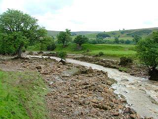
| 10:26 18 July 2007 Image Credit: Paul Crabtree |
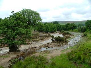
10:48 18 July 2007 Image Credit: Paul Crabtree |
|
The normally small and quiet Thinhope Burn at Knarsdale turned into a raging torrent around 8' above it's normal level. Even though the flood has receeded the amount of water flowing would normally be considered raised. The water level would have been approximately 3' deep over the boulders now strewn over what was previously grass in the lefthand image. In the righthand image the water level reached the small bush on the bank edge on the right. This area of land has a noticable fall, as evidenced by the fast flowing water. It would have been a pretty spectacular, if not frightening, sight during the flood. |
||
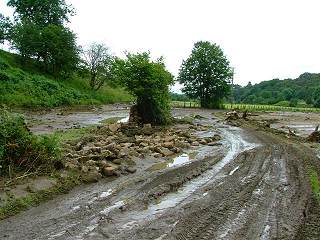 |
The flash flood swept through destroying all before it. Drystone walls not just toppled but strewn out like throwing a handfull of gravel. Trees and bushes making up hedgrows uprooted and carried away. Water depth here maybe only 2' but still flowing very fast. This is a tarmaced road, not what it appears to be a rutted, muddy farm track. |
| 10:09 18 July 2007 Image Credit: Paul Crabtree |
| Howhill Weather - Photos |

 This page is standards compliant |
Updated: Sun 7 Jun 2009, 14:44 BST |