The Weather at Howhill
Photographs - 08 January 2005
Over 3" of rain fell over the catchment area of the River Eden and its tributaries in the 48 hours ending in the early hours of Saturday 8th January 2005. Shap recorded nearly 196mm (7.7") from 0900 on the 6th to 0900 on the 8th. The ground was already saturated after a wet second half of December and first week of January. Consequently most of the rainfall ran straight off instead of soaking in and being released in a more controlled manner.
This extreme amount of run off brought severe flooding in the Eden valley and the worst floods in Carlisle since the 1820's. In the mid afternoon of Saturday 8th 90,000 tonnes/min were, literally, flowing through Carlisle, the biggest passage of water for the Eden and the 2nd biggest for the UK.
The Eden was not the only river to overtop its flood defences. The River Tyne flooded at Corbridge and a tree being washed down the river ruptured two water mains 1.5m below the river bed cutting the drinking water supply to Hexham.
There is lots of coverage of the floods in Carlisle but not much from elsewhere. Below are a few images collected from the web of the flood and damage to the A686 at Langwathby Bridge.
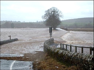 |
View of where the A686 Penrith to Alston road should be. This road did have hedges each side as can be seen in the distance. Note that the water level has receded a bit. |
| Image Credit: Michelle Hall |
 |
A closer view of the downstream side of the road. |
| Image Credit: Tom Scott |
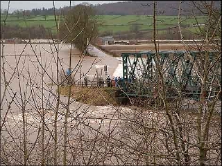 |
Wider view of bridge and flood. The base of the bridge is normally 15 feet or so above the water level. The river runs in a moderately deep cut here with levees which are completely submerged. |
| Image Credit: Michelle Hall |
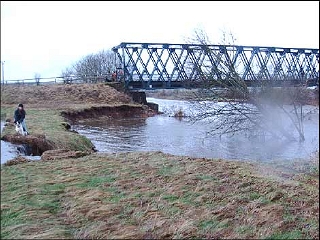 |
Washed away bank, it used to have trees on the side leading down to the river along the line of the one left behind to the bridge abutment. This area is to the left of the bridge in the image above. |
| Image Credit: Katherine Bardsley |
 |
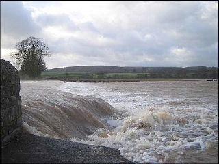
The plunge pool, a good 6 foot drop to the water level and that water isn't shallow as you can see below. |
| Image Credit: Rob Thomas |
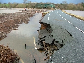 |
This flood was very near to completely washing out the road. The bridge and damaged section was reopened to traffic on the 11th, albeit only a single lane under traffic light control. |
| Image Credit: Paul Crabtree |
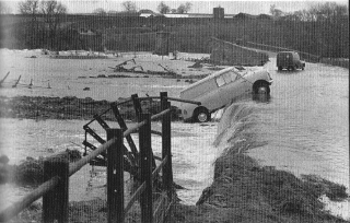 |
Of course the River Eden has flooded here before. Here is an image from 1968 when the original red sandstone bridge was washed away. The walls leading up to where the bridge was are still present, along with the abutments. The current bailey bridge was erected in 1968 and is rumored to be countries longest lasting "temporary" bridge. The Langwathby Parish Council site has more information about the 1968 flood and history of the bridge. BBC Cumbria Memories of Langwathby bridge. |
| Image Credit: Unknown |
| Howhill Weather - Photos |

 This page is standards compliant |
Updated: Sun 7 Jun 2009, 14:55 BST |